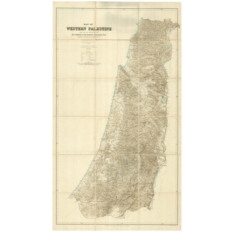
Map of Western Palestine from surveys conducted for the Committee of the Palestine Exploration Fund. London: Stanford's Geographical Establishment, 1881. Original colour. Zincograph, dissected and laid on linen, total 1600 x 960mm, folded into original clo
Map of Western Palestine from surveys conducted for the Committee of the Palestine Exploration Fund. London: Stanford’s Geographical Establishment, 1881. Original colour. Zincograph, dissected and laid on linen, total 1600 x 960mm, folded into original cloth boards. An example of the reduced edition of the first scientific map of the Ottoman province of Palestine, surveyed by two lieutenants of the British Army, Claude Reignier Conder (1848-1910) and Horatio Herbert Kitchener (1850-1916), for the Palestine Exploration Fund. The survey was begun in 1871 by Captain Richard Warren Stewart and Charles Tyrwhitt-Drake. This version, on a scale of three-eighths of an inch to a mile, was published the following year, with ‘special editions’ overprinted to show ‘the Divisions of The Natural Drainage and the Mountain Ranges’, ‘The New Testament, also The Talmud and Josephus’, and ‘The Old Testament, the Apocrypha and Josephus’. The success of this map led to Kitchener being tasked with a similar map of Cyprus, on 15 sheets, published 1885. He rose through the ranks of the British Army, becoming a Field Marshal and Secretary of War during the Great War, finding fame as the face of the ‘Your Country Needs You’ recruitment campaign. When the ship he was aboard was torpedoed in 1916, he was the highest-ranking British officer to be killed in the War.
Dimensions960 1600 mmCartographerCONDER, C.R. & KITCHENER, H.H.Date1881Extra InfoMap of Western Palestine from surveys conducted for the Committee of the Palestine Exploration Fund.PublicationLondon: Stanford’s Geographical Establishment, 1881. Original colour. Zincograph, dissected and laid on linen, total 1600 x 960mm, folded into original cloth boards.ConditionA good example.
| Design Period | Before 1890 |
|---|---|
| Year | 1881 |
| Production Period | Before 1890 |
| Country of Manufacture | Cyprus |
| Style | Vintage |
| Detailed Condition |
Good This vintage/antique item may have some wear such as scratches and other signs of ageing. |
| Product Code | ZHV-2150158 |
| Materials | Linen |
| Color | Beige |
| Weight Range | Standard Between 40kg and 80kg |
| Duties Notice | Import duty is not included in the prices you see online. You may have to pay import duties upon receipt of your order. |


39 Martin Luther King, Junior Memorial Expressway, Tulsa, Oklahoma 74013, United States
Email:[email protected]
Reviews
There are no reviews yet.