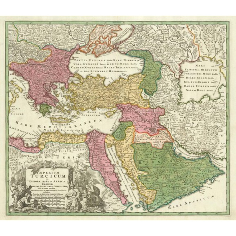
Imperium Turcicum in Europa, Asia et Africa... Nuremberg, c.1720. Original colour. 500 x 590mm. A decorative map of the Turkish Empire, covering Greece, the Black Sea and Ukraine, Syria, the Holy Land, Arabia, Egypt and the Mediterranean coast of Libya. Th
Imperium Turcicum in Europa, Asia et Africa… Nuremberg, c.1720. Original colour. 500 x 590mm. A decorative map of the Turkish Empire, covering Greece, the Black Sea and Ukraine, Syria, the Holy Land, Arabia, Egypt and the Mediterranean coast of Libya. The Caspian Sea is shown, still need mapped properly.
Dimensions590 500 mmCartographerHOMANN, Johann Baptist.Date1720Extra InfoImperium Turcicum in Europa, Asia et AfricaPublicationNuremberg, c.1720. Original colour. 500 x 590mm.ConditionA very fine example.ReferencesTIBBETTS: 257.
| Design Period | Before 1890 |
|---|---|
| Year | 1720 |
| Production Period | Before 1890 |
| Country of Manufacture | Egypt |
| Style | Vintage, Empire |
| Detailed Condition |
Good This vintage/antique item may have some wear such as scratches and other signs of ageing. |
| Product Code | ZHV-2150195 |
| Color | Green, pink |
| Weight Range | Standard Between 40kg and 80kg |
| Duties Notice | Import duty is not included in the prices you see online. You may have to pay import duties upon receipt of your order. |
39 Martin Luther King, Junior Memorial Expressway, Tulsa, Oklahoma 74013, United States
Email:[email protected]
Reviews
There are no reviews yet.