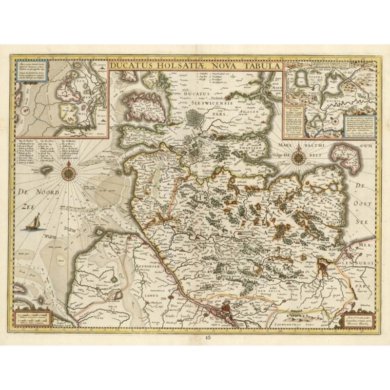
Ducatus Holsatiae Nova Tabula. Amsterdam, c.1632, blank verso. Original colour. 385 x 510mm. A map of the Duchy of Holstein as part of the Holy Roman Empire. Dimensions510 385 mmCartographerHONDIUS, Henricus.Date1632Extra InfoDucatus Holsatiae Nova Tabula.
Ducatus Holsatiae Nova Tabula. Amsterdam, c.1632, blank verso. Original colour. 385 x 510mm. A map of the Duchy of Holstein as part of the Holy Roman Empire.
Dimensions510 385 mmCartographerHONDIUS, Henricus.Date1632Extra InfoDucatus Holsatiae Nova Tabula.PublicationAmsterdam, c.1632, blank verso. Original colour. 385 x 510mm.ConditionA good example.
| Design Period | Before 1890 |
|---|---|
| Year | 1632 |
| Production Period | Before 1890 |
| Country of Manufacture | Denmark |
| Style | Vintage |
| Detailed Condition |
Good This vintage/antique item may have some wear such as scratches and other signs of ageing. |
| Product Code | ZHV-2150206 |
| Materials | Paper |
| Color | Beige |
| Weight Range | Standard Between 40kg and 80kg |
| Duties Notice | Import duty is not included in the prices you see online. You may have to pay import duties upon receipt of your order. |
39 Martin Luther King, Junior Memorial Expressway, Tulsa, Oklahoma 74013, United States
Email:[email protected]
Reviews
There are no reviews yet.