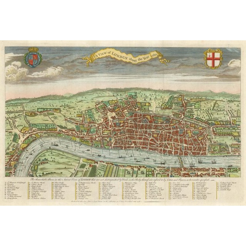
A View of London about the Year 1560. London, 1738. Coloured. 310 x 475mm. A reduced version of one of the first plans of London, incorrectly attributed to Agas. The style is much the same as Braun & Hogenberg, with the buildings shown in profile. St Paul'
A View of London about the Year 1560. London, 1738. Coloured. 310 x 475mm. A reduced version of one of the first plans of London, incorrectly attributed to Agas. The style is much the same as Braun & Hogenberg, with the buildings shown in profile. St Paul’s Cathedral is in the centre of the map, London Bridge has buildings on it, and The Globe and the Bull-Baiting Ring can be seen on the south bank of the river. Published as the frontispiece to Maitland’s ‘History of London’.
Dimensions475 310 mmCartographerAGAS, Ralph.Date1738Extra InfoA View of London about the Year 1560.PublicationLondon, 1738. Coloured. 310 x 475mm.ConditionA good example.
| Design Period | Before 1890 |
|---|---|
| Year | 1560 |
| Production Period | Before 1890 |
| Style | Vintage |
| Detailed Condition |
Good This vintage/antique item may have some wear such as scratches and other signs of ageing. |
| Product Code | ZHV-2150200 |
| Materials | Paper |
| Color | Green, blue |
| Weight Range | Standard Between 40kg and 80kg |
| Duties Notice | Import duty is not included in the prices you see online. You may have to pay import duties upon receipt of your order. |


39 Martin Luther King, Junior Memorial Expressway, Tulsa, Oklahoma 74013, United States
Email:[email protected]

Reviews
There are no reviews yet.