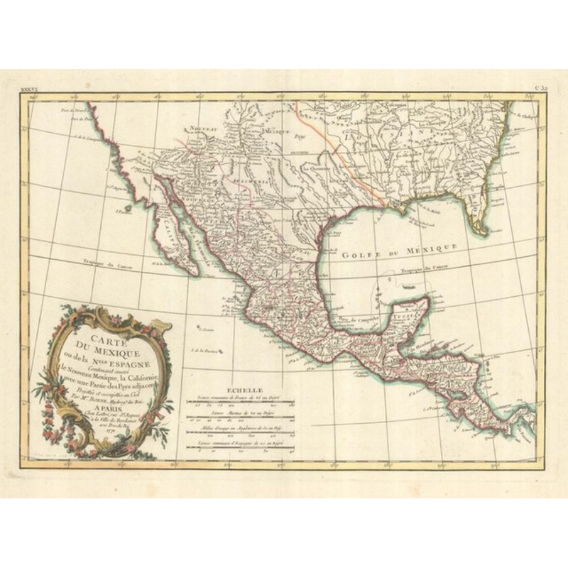
Map of Mexico or New Spain Also containing New Mexico, California, with part of the adjacent countries.... Paris: Jean Lattr?, 1771. Old color. 310 x 430mm. A map of Mexico, but showing North America as far north as Chesapeake Bay and south to Panama, with
Map of Mexico or New Spain Also containing New Mexico, California, with part of the adjacent countries…. Paris: Jean Lattr?, 1771. Old color. 310 x 430mm. A map of Mexico, but showing North America as far north as Chesapeake Bay and south to Panama, with Baja California and New Mexico including Santa F?. Also shows good detail in Texas and along the Rio Grande River, Rio Colorado and Gila. A number of early settlements and Indian tribes are shown.The map marks Jesuit Missions and tribal areas.
Dimensions430 310 mmCartographerBONNE, Rigobert.Date1771Extra InfoMap of Mexico or New Spain Also containing New Mexico, California, with Part of the Adjacent Countries.PublicationParis: Jean Lattr?, 1771. Old color. 310 x 430mm.ConditionA good example.
| Design Period | Before 1890 |
|---|---|
| Year | 1771 |
| Production Period | Before 1890 |
| Country of Manufacture | India |
| Style | Vintage |
| Detailed Condition |
Good This vintage/antique item may have some wear such as scratches and other signs of ageing. |
| Product Code | ZHV-2150204 |
| Materials | Paper |
| Color | Beige |
| Weight Range | Standard Between 40kg and 80kg |
| Duties Notice | Import duty is not included in the prices you see online. You may have to pay import duties upon receipt of your order. |

39 Martin Luther King, Junior Memorial Expressway, Tulsa, Oklahoma 74013, United States
Email:[email protected]

Reviews
There are no reviews yet.