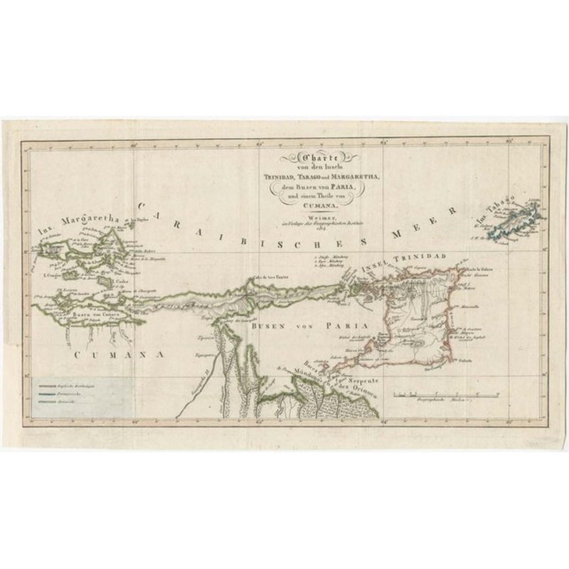
Charter of the islands of Trinidad, Tabago and Margaretha, the bosom of Paria, and a part of Cumana. Weimar: Publishers of the Geographer. Institute, 1814. Original colour. 235x420mm. A map of Trinidad, Tobago and Isla de Margarita, with part of the Venezu
Charter of the islands of Trinidad, Tabago and Margaretha, the bosom of Paria, and a part of Cumana. Weimar: Publishers of the Geographer. Institute, 1814. Original colour. 235x420mm. A map of Trinidad, Tobago and Isla de Margarita, with part of the Venezuelan coast. Tobago is still shown as a French colony, prior to it being ceded to Britain in the Treaty of Paris that seemingly ended the Napoleonic Wars later in 1814, the year of publication. Jean-Francois Dauxion-Lavaysse (c.1770-c.1830), was a planter on Trinidad when Britain took the island from the French in 1797. This map comes from ‘Journey to the islands of Trinidad, Tabago and Margaretha, as well as to various parts of Venezuela’, his account of the islands, which was the only translation of the work..
Dimensions420 235 mmCartographerDAUXION-LAVAYSSE, Jean-Francois.Date1814Extra InfoChart of the islands of Trinidad, Tabago and Margaretha, the bosom of Paria, and a part of Cumana.PublicationWeimar: Verlage des Geograph. Institute, 1814. Original colour. 235 x 420mm.ConditionA good example.
| Design Period | Before 1890 |
|---|---|
| Year | 1814 |
| Production Period | Before 1890 |
| Country of Manufacture | France |
| Style | Vintage |
| Detailed Condition |
Good This vintage/antique item may have some wear such as scratches and other signs of ageing. |
| Product Code | ZHV-2150201 |
| Materials | Paper |
| Color | Beige |
| Weight Range | Standard Between 40kg and 80kg |
| Duties Notice | Import duty is not included in the prices you see online. You may have to pay import duties upon receipt of your order. |


39 Martin Luther King, Junior Memorial Expressway, Tulsa, Oklahoma 74013, United States
Email:[email protected]
Reviews
There are no reviews yet.