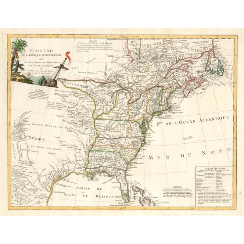
Etats-Unis de L'Amerique Septentrionale Avec Les Isles Royal, de Terre Neuve, de St. Jean, L'Acadie &c. Paris, Delamarche, 1785. Coloured. 500 x 650mm. A large map of the United States of America published only two years after the Treaty of Paris ended the
Etats-Unis de L’Amerique Septentrionale Avec Les Isles Royal, de Terre Neuve, de St. Jean, L’Acadie &c. Paris, Delamarche, 1785. Coloured. 500 x 650mm. A large map of the United States of America published only two years after the Treaty of Paris ended the American Revolutionary War. The map extends into both Canada and Mexico, noting the locations of the various tribes and marking ‘Tecas’. Bottom right is a list of the first 13 States and their capitals, with a list of 10 new states planned by Thomas Jefferson: Silvania, Michigania, Chersonesus, Arsenistpia, Metropotamia, Illinoia, Saratoga, Washington, Polypotamia, and Pelisypia.
Dimensions650 500 mmCartographerDELAMARCHE, Charles Fran?ois.Date1785Extra InfoEtats-Unis de L’Amerique Septentrionale Avec Les Isles Royal, de Terre Neuve, de St. Jean, L’Acadie &c.PublicationParis, Delamarche, 1785. Coloured. 500 x 650mm.ConditionA good example.
| Design Period | Before 1890 |
|---|---|
| Year | 1785 |
| Production Period | Before 1890 |
| Country of Manufacture | Canada |
| Style | Vintage |
| Detailed Condition |
Good This vintage/antique item may have some wear such as scratches and other signs of ageing. |
| Product Code | ZHV-2150154 |
| Materials | Paper |
| Color | Beige |
| Weight Range | Standard Between 40kg and 80kg |
| Duties Notice | Import duty is not included in the prices you see online. You may have to pay import duties upon receipt of your order. |


39 Martin Luther King, Junior Memorial Expressway, Tulsa, Oklahoma 74013, United States
Email:[email protected]

Reviews
There are no reviews yet.