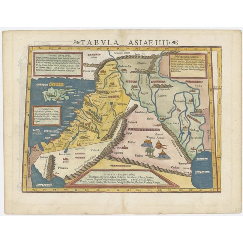
Tabula Asiae IIII. Basle, c.1550, Latin text edition. Coloured woodcut. Printed area 265 x 345mm. A map of the Eastern Mediterranean and the Middle East from Munster's edition of Ptolemy's Geography. It shows Cyprus, the Holy Land, Mesopotamia, with Babylo
Tabula Asiae IIII. Basle, c.1550, Latin text edition. Coloured woodcut. Printed area 265 x 345mm. A map of the Eastern Mediterranean and the Middle East from Munster’s edition of Ptolemy’s Geography. It shows Cyprus, the Holy Land, Mesopotamia, with Babylon.
Dimensions345 265 mmCartographerMUNSTER, Sebastian.Date1552Extra InfoTabula Asiae IIII.PublicationBasle, c.1550, Latin text edition. Coloured woodcut. Printed area 265 x 345mm.ConditionA good example.
| Design Period | Before 1890 |
|---|---|
| Year | 1550 |
| Production Period | Before 1890 |
| Country of Manufacture | Cyprus |
| Style | Vintage |
| Detailed Condition |
Good This vintage/antique item may have some wear such as scratches and other signs of ageing. |
| Product Code | ZHV-2150177 |
| Materials | Paper |
| Color | Beige, blue |
| Weight Range | Standard Between 40kg and 80kg |
| Duties Notice | Import duty is not included in the prices you see online. You may have to pay import duties upon receipt of your order. |
39 Martin Luther King, Junior Memorial Expressway, Tulsa, Oklahoma 74013, United States
Email:[email protected]
Reviews
There are no reviews yet.