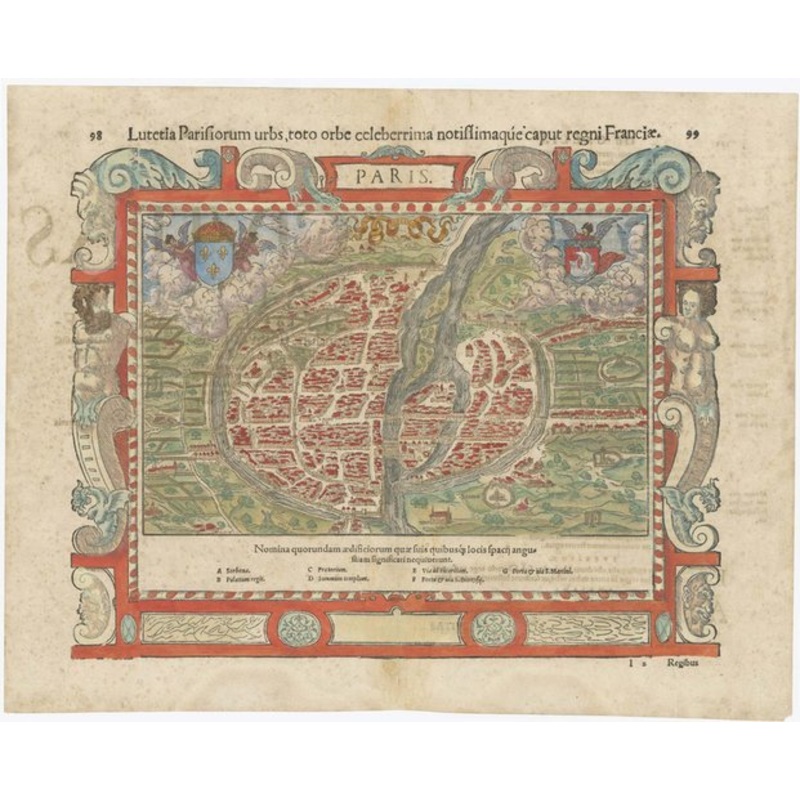
Paris. Lutetia Parisiorum urbs, toto orbe celeberrima notissimaque, caput regni Franciae. Basle, c.1560, Latin text edition. Coloured. Woodcut, printed area 280 x 340mm. A fine city-plan view of Paris, with the buildings shown in profile including the Roya
Paris. Lutetia Parisiorum urbs, toto orbe celeberrima notissimaque, caput regni Franciae. Basle, c.1560, Latin text edition. Coloured. Woodcut, printed area 280 x 340mm. A fine city-plan view of Paris, with the buildings shown in profile including the Royal Palace and Town Hall, listed in the index below the image. Munster published two plans of Paris: this is the smaller map but has an elaborate woodcut border featuring atlas.
Dimensions340 280 mmCartographerMUNSTER, Sebastian.Date1560Extra InfoParis. Lutetia Parisiorum urbs, toto orbe celeberrima notissimaque, caput regni Franciae.PublicationBasle, c.1560, Latin text edition. Coloured. Woodcut, printed area 280 x 340mm.ConditionA good example.
| Design Period | Before 1890 |
|---|---|
| Year | 1560 |
| Production Period | Before 1890 |
| Style | Vintage |
| Detailed Condition |
Good This vintage/antique item may have some wear such as scratches and other signs of ageing. |
| Product Code | ZHV-2150176 |
| Materials | Paper |
| Color | Beige, red, green |
| Weight Range | Standard Between 40kg and 80kg |
| Duties Notice | Import duty is not included in the prices you see online. You may have to pay import duties upon receipt of your order. |
39 Martin Luther King, Junior Memorial Expressway, Tulsa, Oklahoma 74013, United States
Email:[email protected]

Reviews
There are no reviews yet.