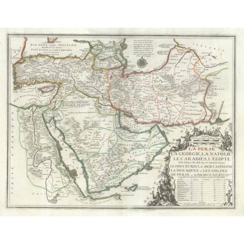
Persia, Georgia, ANatolia, the Arabias, Egypt and the course of the Nile where there is also the Euxine Bridge, the Caspian Sea, the Red Sea and the Gulfs of Persia and Ormus. Paris: Guillaume Danet, 1724. Fine original color. 425 x 555mm. A map showing th
Persia, Georgia, ANatolia, the Arabias, Egypt and the course of the Nile where there is also the Euxine Bridge, the Caspian Sea, the Red Sea and the Gulfs of Persia and Ormus. Paris: Guillaume Danet, 1724. Fine original color. 425 x 555mm. A map showing the Turkish Empire in Asia, with Arabia, Persia, Egypt and the southern Caucasus. De Fer proportions to show the course of the Nile, but puts the source, ‘Lac Dembas’, in northern Ethiopia. This example was published by De Fer’s son-in-law and successor, Guillaume Danet. Additional informationDimensions555 425 mmCartographerFER, Nicolas de.Date1720Extra InfoPersia, Georgia, Natolia, The Arabias, Egypt and the Course of the Nile where there is also The Euxine Bridge The Caspian Sea The Red Sea and The Gulfs of Persia and Ormus.PublicationParis: Guillaume Danet, 1724. Fine original color. 425 x 555mm.ConditionA good example.References
| Design Period | Before 1890 |
|---|---|
| Year | 1724 |
| Production Period | Before 1890 |
| Country of Manufacture | Egypt |
| Style | Antique |
| Detailed Condition |
Good This vintage/antique item may have some wear such as scratches and other signs of ageing. |
| Product Code | ZHV-2150173 |
| Materials | Ink, Paper |
| Color | White |
| Width |
56 cm 21.9 inch |
| Height |
43 cm 16.7 inch |
| Weight Range | Standard Between 40kg and 80kg |
| Duties Notice | Import duty is not included in the prices you see online. You may have to pay import duties upon receipt of your order. |
39 Martin Luther King, Junior Memorial Expressway, Tulsa, Oklahoma 74013, United States
Email:[email protected]
Reviews
There are no reviews yet.