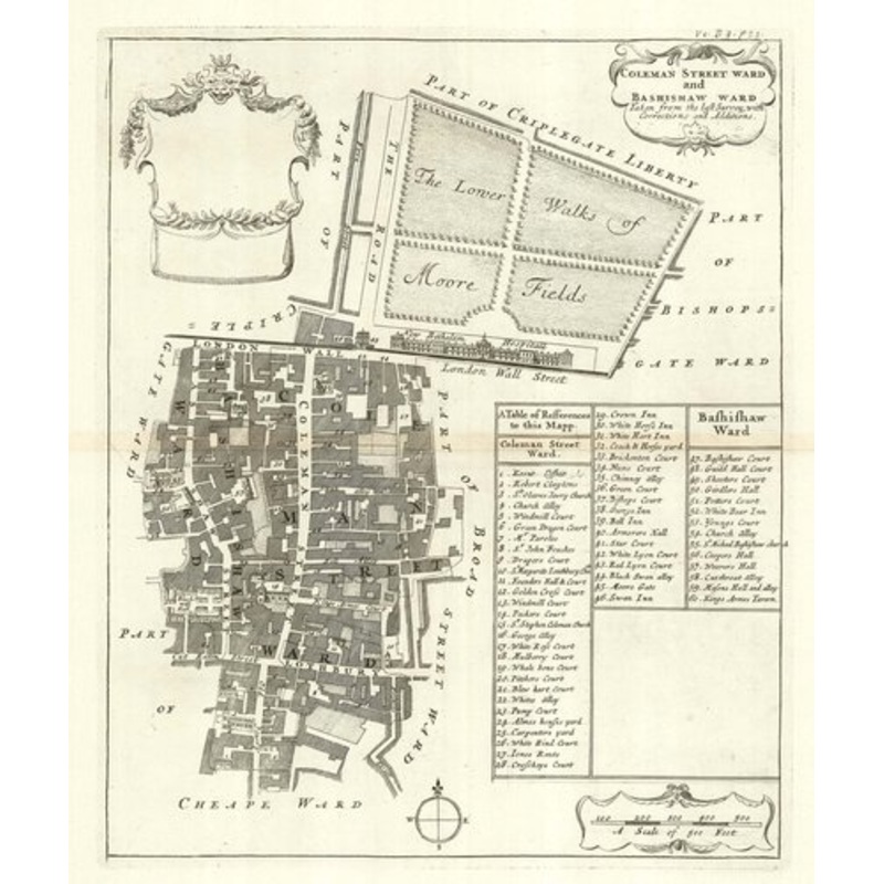
Coleman Street Ward and Bashisaw Ward Taken from the last Survey with Corrections and Additions. London: Awnsham Churchill, John Knapton et al, 1720. 360 x 300mm. A detailed plan of the wards of Coleman Street and Bassishaw, showing the area around Moorgat
Coleman Street Ward and Bashisaw Ward Taken from the last Survey with Corrections and Additions. London: Awnsham Churchill, John Knapton et al, 1720. 360 x 300mm. A detailed plan of the wards of Coleman Street and Bassishaw, showing the area around Moorgate in the City of London. The old London Wall runs across the map, with Moorgate in the centre, Moorfields at the top, next to Bethlehem Hospital. A 60-point key references various place names. The map was engraved by Richard Blome c.1695 but not published until 1720, with his name removed from the title. In 1695 William III granted Blome a privilege to publish ‘A Survey or of the citties of London and Westminstr’. Although the British Library holds examples of his maps with Blome’s name, none were published until John’s Strype’s ‘A Survey of the Cities of London and Westminster’, a continuation of ‘Stow’s Survey’. This example comes from the first edition, with no apparent attempt to update Blome’s mapping.
Dimensions300 360 mmCartographerBLOME, Richard.Date1720Extra InfoColeman Street Ward and Bashisaw Ward Taken from the last Survey with Corrections and Additions.PublicationLondon: Awnsham Churchill, John Knapton et al, 1720. 360 x 300mm.ConditionA good example.
| Design Period | Before 1890 |
|---|---|
| Year | 1720 |
| Production Period | Before 1890 |
| Style | Vintage |
| Detailed Condition |
Good This vintage/antique item may have some wear such as scratches and other signs of ageing. |
| Product Code | ZHV-2150205 |
| Materials | Paper |
| Color | Beige |
| Weight Range | Standard Between 40kg and 80kg |
| Duties Notice | Import duty is not included in the prices you see online. You may have to pay import duties upon receipt of your order. |

39 Martin Luther King, Junior Memorial Expressway, Tulsa, Oklahoma 74013, United States
Email:[email protected]
Reviews
There are no reviews yet.