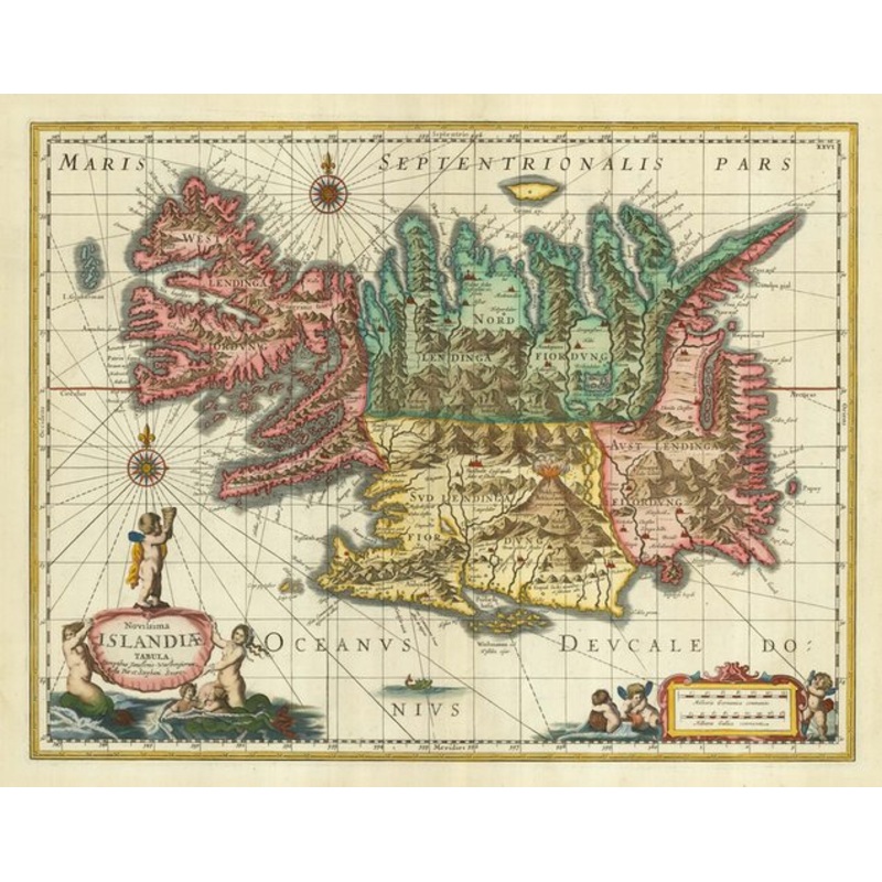
Novissima Islandiae Tabula. Sumptimus Janssonio-Waesbergiorum, Moses Pitt et Stephani Swart. Oxford: Moses Pitt, Steven Sward and Johannes Jansson a Waesberge, 1680, blank verso. Coloured. 380 x 500mm. A fine map of Iceland, based on a map by Joris Carl (1
Novissima Islandiae Tabula. Sumptimus Janssonio-Waesbergiorum, Moses Pitt et Stephani Swart. Oxford: Moses Pitt, Steven Sward and Johannes Jansson a Waesberge, 1680, blank verso. Coloured. 380 x 500mm. A fine map of Iceland, based on a map by Joris Carl (1601-25), a pilot from Enkhuizen, decorated with ornate cartouches for the title and scale, a pair of compass roses and a vignette sea-monster. This example comes from the ill-fated attempt to publish a multi-volume atlas in Oxford, under the supervision of Moses Pitt (c.1639-97). Only four volumes were published before Pitt was declared banckrupt and sent to Fleet Prison. For this edition the title was altered, the two cartouches redrawn and gradule lines added.
Dimensions500 380 mm
Cartographer JANSSON, Jan.Date1680
Novissima Islandiae Tabula. Sumptimus Janssonio-Waesbergiorum, Moses Pitt et Stephani Swart.PublicationOxford: Moses Pitt, Steven Sward and Johannes Jansson a Waesberge, 1680, blank verso. Coloured. 380 x 500mm.
Condition A good example.References
| Design Period | Before 1890 |
|---|---|
| Year | 1680 |
| Production Period | Before 1890 |
| Country of Manufacture | Iceland |
| Style | Vintage |
| Detailed Condition |
Good This vintage/antique item may have some wear such as scratches and other signs of ageing. |
| Product Code | ZHV-2150142 |
| Materials | Paper |
| Color | Beige, red, green |
| Weight Range | Standard Between 40kg and 80kg |
| Duties Notice | Import duty is not included in the prices you see online. You may have to pay import duties upon receipt of your order. |


39 Martin Luther King, Junior Memorial Expressway, Tulsa, Oklahoma 74013, United States
Email:[email protected]
Reviews
There are no reviews yet.